| Landkarten Grossbritannien - Irland | Kunsthandlung Johannes Müller |
|
|
|
| Channel Islands |
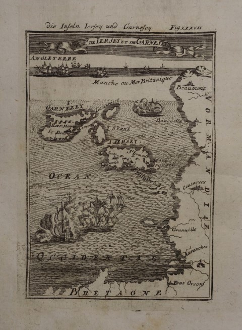 I de Iersey et de Garnesey / die Inseln Iersey und Garnesey. Kupferstich aus A. M. Mallet "Beschreibung Des gantzen Welt-Kreises" Frankfurt, J. A. Jung 1719, 14,5 x 10 cm
Alain Manesson Mallet (* 1630 in Paris; 1706 ebenda) war ein französischer Kartograph und Ingenieur. Sein Hauptwerk "Description de LíUnivers" erschien erstmals 1683 in fünf Bänden in Paris.- Schönes, breitrandiges Exemplar, ohne Text auf der Rückseite. # Engraved map shows the Channel Isles Jersey and Garnezey.- Nice, wide-margined copy from the second, revised German edition of Mallet s "Description de l Univers" with additional German title on top; without text on the back. (Great Britain, United Kingdom) |
|
| Bestellnummer:L2324 | EUR 50,00 / Bestellen |
| Cumbria and Westmorland |
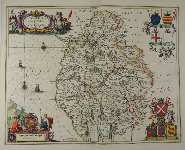 Cumbria & Westmoria. Vulgo Cumberland & Westmorland. Altkolorierte Kupferstich-Karte. Amsterdam, Johannes Janssonius um 1650, 42 x 53,5 cm
Schönes Exemplar mit kräftigem Kolorit. # Engraved map with original colours.- (Great Britain, United Kingdom) |
|
| Bestellnummer:L2298 | EUR 280,00 / Bestellen |
| England |
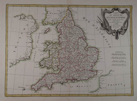 Carte Du Royaume DíAngleterre Projettée et assujiettie aux Observations Astronomiques par Mr. Bonne, Hydro. du Roi. Grenzkolorierte Kupferstich-Karte n. Rigobert Bonne aus "Atlas Moderne ou Collection de Cartes sur Toutes les Parties du Globe Terrestre". Paris, Jean Lattré 1771, 30 x 42 cm
# Decorative engraved map with original outline hand-colouring, showing Scotland and the Orkney and Shetland Islands, Outer Hebrides. Wide margins.- (Great Britain, United Kingdom) |
|
| Bestellnummer:L1941 | EUR 140,00 / Bestellen |
| England |
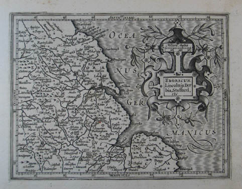 Eboracum, Lincolnia, Derbia, Stafford, etc. Kupferstich-Karte aus Mercator "Atlas Minor". Amsterdam, Hondius 1607, 12,5 x 17 cm
Im Randbereich leicht braunfleckig. # Map of Norfolk, Leicestershire, Lincolnshire, Nottinghamshire, South Yorkshire (Sheffield), West Yorkshire (Leeds), North Yorkshire, Humberside and Cleveland. (Nordostengland, Great Britain, United Kingdom) |
|
| Bestellnummer:L991 | EUR 85,00 / Bestellen |
| England |
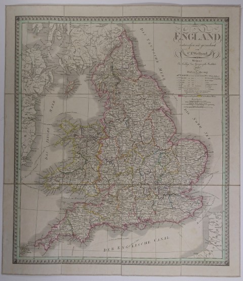 England entworfen und gezeichnet von C. F. Weiland. Grenzkolor. Kupferstich-Karte v. Carl Jos. Maedel in 12 Segmenten auf Lwd. aufgezogen. Weimar, Geogr. Institut 1830, 54,5 x 47 cm, mehrf. gefalt. in Pbd.-Schuber d. Zt.
Der Kartograph Carl Ferdinand Weiland (* 1782; 18. Mai 1847 in Gera) wirkte beim geographischen Institut in Weimar und wurde 1817 Nachfolger von Friedrich Wilhelm Streit.- Copper engraving with original outline color mounted on canvas in 12 segments.- (Great Britain, United Kingdom) |
|
| Bestellnummer:L2569 | EUR 110,00 / Bestellen |
| England |
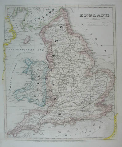 England. Grenzkolorierte Stahlstich-Karte von Radefeld aus "Meyer`s Zeitungs-Atlas". Hildburghausen, Bibliograph. Institut 1850, 25 x 18,5 cm
Der Kartograph Carl Christian Franz Radefeld (Jena, 1788 - 1874) wurde bekannt durch seine Zusammenarbeit mit dem Verleger J. Meyer und seinem Haus Bibliographisches Institut. Insbesondere durch den "Atlas zum Handgebrauche für die Gesammte Erdbeschreibung" von 1841 und des "Grossen Hand-Atlas" von 1846.- (England, Wales, Great Britain, United Kingdom) |
|
| Bestellnummer:L1241 | EUR 40,00 / Bestellen |
| England |
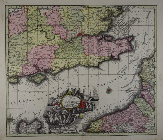 La Plus Grande Partie de la Manche, qui contient Les Cotes d Angleterre et celles de France. Altkolorierte Kupferstich-Karte von Matthäus Seutter, Augsburg um 1740, 49 x 57 cm
# Engraved map with original colours showing the southeast of England, the english channel and northern France.- (Südostengland, Ärmelkanal, Nordfrankreich, Great Britain, Channel) |
|
| Bestellnummer:L2191 | EUR 240,00 / Bestellen |
| England |
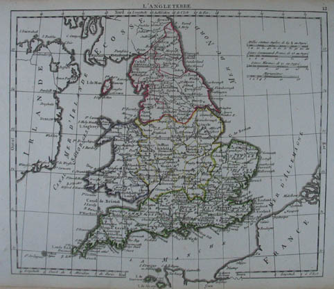 LíAngleterre. Grenzkolorierte Kupferstich-Karte aus Herisson "Atlas portatif" Paris, Desray 1806, 18 x 21,5 cm
# Copper engraving with original outline color.- (Great Britain, United Kingdom) |
|
| Bestellnummer:L1477 | EUR 55,00 / Bestellen |
| England |
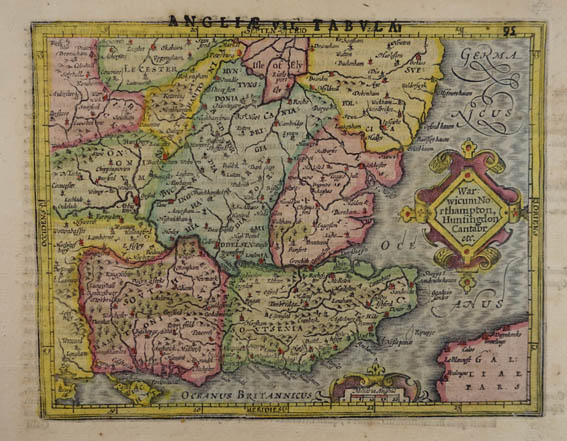 Warwicum Northampton, Huntingdon Canatbr etc. Altkolorierte Kupferstich-Karte aus Mercator "Atlas Minor". Amsterdam, Hondius 1621, 14 x 18 cm
Mit Überschrift: Angliae VII. Tabula.- Verso lateinischer Text # Engraved map with original colours of southeastern England including London, Salisbury, Oxford, Cambridge, Leicester and Norwich and the Isle of Wight. (Südostengland, Great Britain, United Kingdom) |
|
| Bestellnummer:L1844 | EUR 75,00 / Bestellen |
| England |
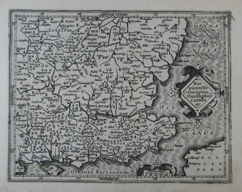 Warwicum Northampton, Huntington Cantabr etc. Kupferstich-Karte aus Mercator "Atlas Minor". Amsterdam, Hondius 1607, 14 x 18 cm
Im Randbereich leicht braunfleckig. # map of southeastern England including London, Salisbury, Oxford, Cambridge, Leicester and Norwich and the Isle of Wight. (Südostengland, Great Britain, United Kingdom) |
|
| Bestellnummer:L993 | EUR 90,00 / Bestellen |
| England / Wales |
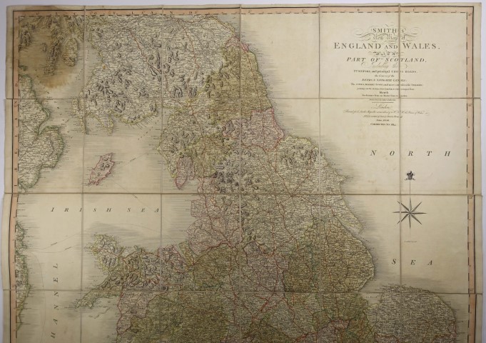 Smith`s new Map of England and Wales, with part of Scotland, including the Turnpike, and principal Cross Roads, the Course of the Rivers, & navigable Canals; ... Grenzkolor. Kupferstich-Karte in 36 Segmenten auf Lwd. aufgezogen. London, C. Smith June 1806. Corrected to 1814, 114 x 93 cm, mehrf. gefalt. in Pbd.-Schuber d. Zt. gedr. Deckelschild.
# Large and detailed map by Charles Smith (1768 - 1854), "Engraver and Map Seller Extraordinary to H.R.H. the Prince of Wales."- Engraved map with original outline color mounted on canvas in 12 segments, is filled with detail including turnpike roads, postal roads, canals and churches.- Somewhat stained in places.engraving |
|
| Bestellnummer:L2572 | EUR 150,00 / Bestellen |
| Gibraltar |
 Castellum Gibraltar in Andalusia situm cum celebri freto inter Europam et Africam, annexis circumjacentibus portubus et castellis. Altkolorierte Kupferstich-Karte v. Tobias Conrad Lotter. Augsburg um 1760, 48 x 58 cm
Winzige Wurmspur in der Mittelfalte, sonst gutes Exemplar mit kräftigem Kolorit, gedruckt auf starkem Papier.- # Detailed engraved map with original full coloring of the Gibraltar area in Spain, reaching from Cadiz to Marbella and across the Straits of Gibraltar to to Ceuta and Tangier; below a large map of Gibraltar itself.- Tiny trace of worming in the center fold, otherwise a good copy with strong colouring, printed on strong paper.- (Great Britain, United Kingdom, Spain, Andalusien, Andalucía) |
|
| Bestellnummer:L2428 | EUR 280,00 / Bestellen |
| Gibraltar |
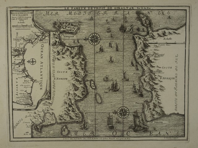 Le fameux detroit de Gibalatar. Kupferstich-Karte v. C. Inselin nach Nicolas de Fer aus "Atlas Curieux". Paris 1705, 23,5 x 31,5 cm
Nicolas de Fer (* 1646; 25. Oktober 1720 in Paris) war einer der führenden französischen Kartographen und Kartenverleger des ausgehenden 17. und beginnenden 18. Jahrhunderts.- Zwei kleine Fehlstellen im Rand. # Detailed engraved map of the Straits of Gibraltar, with a number of sailing vessels, compass roses and topographical details.- Two small blemishes in the margin. (Great Britain, United Kingdom, Spain, Andalusien, Andalucía) |
|
| Bestellnummer:L2254 | EUR 100,00 / Bestellen |
| Gibraltar |
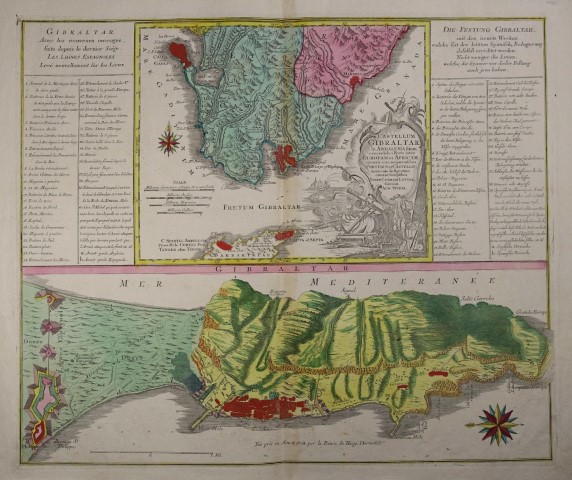
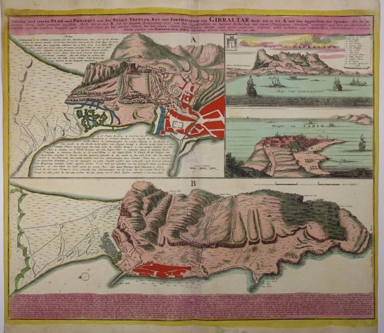 Neuester und exacter Plan und Prospect von der Stadt, Vestung, Bay und Fortification von Gibraltar... Altkolorierte Kupferstich-Karte. Nürnberg, Homann Erben 1733, 48 x 58 cm
zeigt verschiedene Ansichten, Pläne und Befestigungen von Gibraltar und eine Ansicht von Cadiz, mit beschreibendem Text.- Restaurierte Wurmspuren in der Mittelfalte, seitlich etw. knapprandig, kräftiges Kolorit. # Detailed engraved map with original full coloring showing the various views, plans and fortifications of Gibraltar and a view of Cadiz, with descriptive text.- Couple of small worm holes repaired in centerfold. (Great Britain, United Kingdom, Spain, Andalusien, Andalucía) |
|
| Bestellnummer:L2429 | EUR 400,00 / Bestellen |
| Grossbritannien |
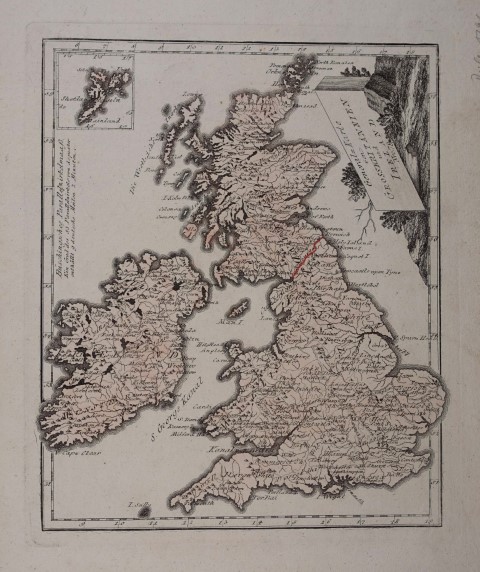
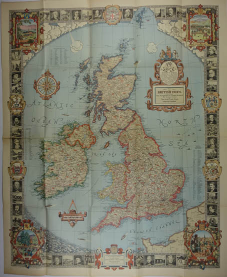 A modern Pilgrim`s Map of the British Isles or more precisely the Kingdom of Great Britain an Northern Ireland and the Irish Free State. Designed by C. E. Riddiford. Farb. Karte. Done in the Map and Art Studios of the National Geographic Magazine. Gilbert Grosvenor, Editor. Washington 1937, 87 x 70,5 cm
Dekorative Karte mit illustriertem Rand mit Porträts, Legende und Verzeichnissen der Grafschaften von Schottland, Irland, Wales und England .- Mehrfach gefaltet. # Original, pictorial map with illustrated border with portraits, legend and lists of the counties of Scotland, Ireland, Wales and England.- Folded several times |
|
| Bestellnummer:L1797 | EUR 60,00 / Bestellen |
| Grossbritannien |
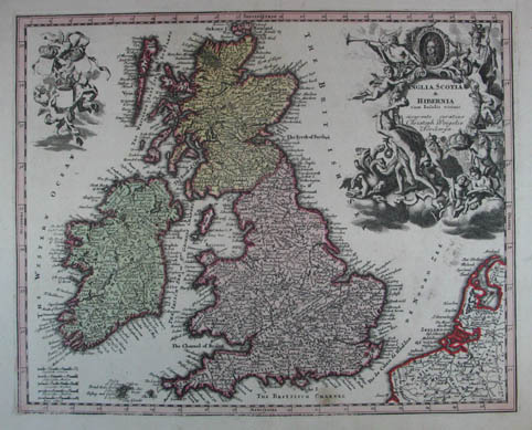 Anglia, Scotia & Hibernia cum Insulis vicinis. Altkolorierte Kupferstich-Karte aus J. D. Köhler "Atlas manualis scholasticus". Nürnberg, Christoph Weigel um 1726, 27 x 34 cm
Für seinen frühen deutschen Schulatlas verwendete der Kupferstecher u. Verleger Johann Christoph Weigel (* 15. Juli 1661 in Redwitz; 3. September 1726 in Nürnberg) meist Vorlagen von Homann und Alain Manesson Mallet.- Ränder gering fleckig, sonst gutes Exemplar ohne Mittelfalte. # Original colour; (Great Britain, United Kingdom) |
|
| Bestellnummer:L1554 | EUR 220,00 / Bestellen |
| Großbritannien |
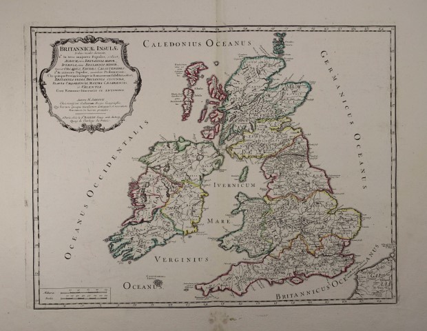 Britannicae Insulae Tribus modis distinctae.... Grenzkolorierte Kupferstich-Karte von Nicolas Sanson / Robert Vaugondy. Paris um 1745
Historische Karte von Großbritannien aus der Zeit des römischen Imperiums mit den einzelnen Stämmen, Clans, römischen Befestigungen, dem Hadrianswall und dem römischen Straßennetz.- Unterer Rand gering fleckig, sonst schönes breitrandiges Exemplar.- # Copper engraved map. Contemporary colored boundaries.- Historical map of the British Isles during the Roman Empire.- Lower edge slightly stained, otherwise a nice, wide-margined copy.- (England, Irland, Schottland, Great Britain, United Kingdom) |
|
| Bestellnummer:L2367 | EUR 180,00 / Bestellen |
| Großbritannien |
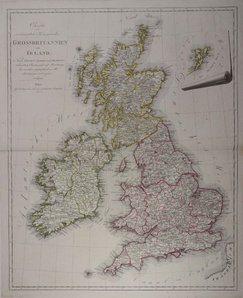 Charte der vereinigten Königreiche Grossbritannien und Irland; Nach Kitchin, Dorret und Beaufortís reducirter Charte, und mit Benützung der neuesten geographischen Bestimmungen entworfen von K. I. Kipferling. Grenzkolorierte Kupferstich-Karte. Wien im Verlage des Kunst- u. Industrie Comptoirs 1805, 60 x 49 cm
Dörflinger II, 557 (KIC 4 / 12) - Tooley III, 33.- Rechts oben kleine Insertkarte von den Shetland Inseln.- Selten.- Karl Joseph Kipferling war Wiener Kartograph u. Kupferstecher aus der ersten Hälfte des 19. Jahrhunderts. Er wirkte in Wien wo er mit Kindermann, Walch und Müller zusammengearbeitet hat.- Gutes Exemplar. # Copper engraved map with original outline coloring.- With a small inset map of the Shetland Islands. (England, Schottland, Irland, Great Britain, United Kingdom) |
|
| Bestellnummer:L2374 | EUR 170,00 / Bestellen |
| Großbritannien |
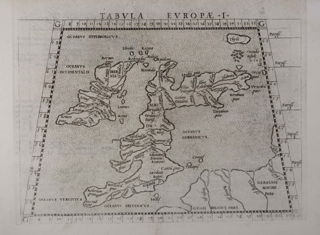 Europae Tabula I. Kupferstich-Karte aus Ptolemaeus - Ruscelli, "La geografia" Venedig 1561, 23 x 32,5 cm (Blattgr.)
# Double-page engraved map from Claudius Ptolemaeus "La geografia di Claudio Tolomeo Alessandrino ... Nuouamente tradotta di Greco in Italiano, da Girolamo Ruscelli. Venice: Vincenzo Valgrisi, 1561.- Historical map of Great Britain. (England, Irland. Great Britain, United Kingdom) |
|
| Bestellnummer:L2372 | EUR 140,00 / Bestellen |
| Großbritannien |
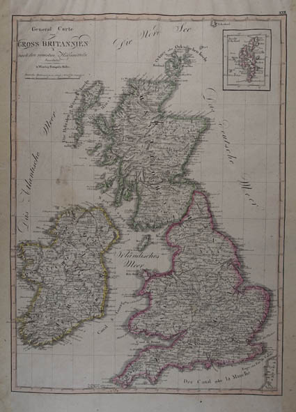 General Carte von Gross Britannien nach den neuesten Hülfsmitteln bearbeitet. Grenzkolorierte Kupferstichkarte von Joseph Dirwald aus "Allgemeiner Hand-Atlas zum Gebrauche für die Jugend in höheren und niedern Schulen, für Kaufleute und Zeitungsleser. Nach den letzten Friedensschlüsen berichtiget". Wien, Tranquillo Mollo 1816, 45 x 32,5 cm
Atlantes Austriaci Mol / Dir B (1816).- Rechts oben Insetkarte der Shetlandinseln.- Seitenränder mit Transparenzpapier verstärkt. # Engraved map with original outline hand-colouring.- (Great Britain, United Kingdom) |
|
| Bestellnummer:L1912 | EUR 120,00 / Bestellen |
| Grossbritannien |
 General-Karte von Grossbritannien und Ireland. Nro 78. Kolorierte Kupferstich-Karte aus Reilly "Schauplatz der fünf Theile der Welt” Wien 1791, 28,5 x 23,5 cm
Atlantes Austriaci I/1, 86 (Rei A 78).- Mit kl. Nebenkarte der Shetlandinseln.- Gutes Exemplar mit zartem Kolorit # Engraved map with contemporary coloring.- (Great Britain, United Kingdom,) |
|
| Bestellnummer:L2470 | EUR 50,00 / Bestellen |
| Grossbritannien |
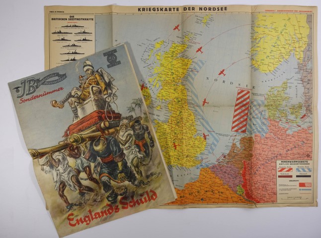 Kriegskarte der Nordsee mit den deutschen, englischen, niederländischen und dänischen Minenwarngebieten sowie mit namentlicher Anführung der englischen Seestreitkräfte. Genehmigt: Oberkommando der Kriegsmarine. Farb. Karte. Wien, Kartogr. Verlag Freissler 1940, 43,5 x 60 cm, mehrf. gefalt., verso mit gedr. Titel.- Beiliegt: Illustrierter Beobachter. Beilage zur Sondernummer "Englands Schuld". Mit 3 farb. Landkarten: Kriegsschauplatz Nordsee / Weltkarte mit England u. seine Kolonien / England (71,5 x 51,5 cm). München, Eher 1939
Am linken Rand: Auflistung der britischen Seestreitkräfte.- Beilage mit kl. Randeinriss u. Randäsuren. # War map of the North Sea during the Second World War with the German, English, Dutch and Danish mine warning areas and a list of the British naval forces.- Enclosed: Illustrierter Beobachter. Supplement to the special issue "Englands Schuld". With 3 col. Maps in colour. (Zweiter Weltkrieg) |
|
| Bestellnummer:L2616 | EUR 50,00 / Bestellen |
| Grossbritannien |
 La Grande Bretagne ou les Royaumes d Angleterre et d Ecosse comme aussi le Royaume d Irlande". Altkolorierte Kupferstich-Karte mit großer unkolor. figürl. Kartusche von M. A. Lotter bei T. C. Lotter in Augsburg 1764, 49 x 58 cm.
Karte von Großbritannien u. Irland.- Breitrandig.- Sehr gutes Exemplar. # Copper engraving with original colour; a very good copy with wide margins. (Great Britain, United Kingdom) |
|
| Bestellnummer:L1032 | EUR 320,00 / Bestellen |
| Grossbritannien |
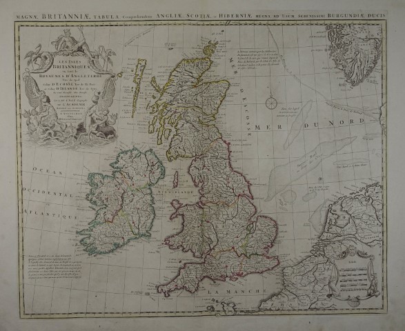 Les Isles Britanniques ou sont le Rme. d Angleterre tire de Sped, celuy d Ecosse tire de Th. Pont &c., et celuy d Irelande tire de Petti. Le tout rectifie par diverses observations Par G. De l Isle geographe de l Academie Royale des Sciences. Grenzkolorierte Kupferstich-Karte von Jean Baptiste Liebaux nach Guillaume de líIsle, Amsterdam, Covens & Mortier um 1730, 48 x 58 cm (Plattenrd.)
Mit lateinischem Übertitel "Magnae Britanniae tabula, comprehendens Angliae, Scotiae, ac Hiberniae Regna, ad usum serenissimi Burgundiae Ducis.".- Der französische Kartograph Guillaume Delisle (* 28. Februar 1675 in Paris; 25. Januar 1726 in Paris) gab zahlreiche Landkarten heraus, die sich durch Eleganz und Schärfe von den früheren Karten unterschieden.- # Copper engraving with original outline color.- (Great Britain, United Kingdom) |
|
| Bestellnummer:L2216 | EUR 300,00 / Bestellen |
| Großbritannien |
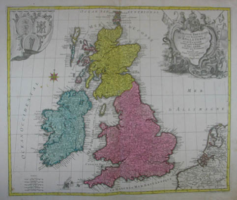
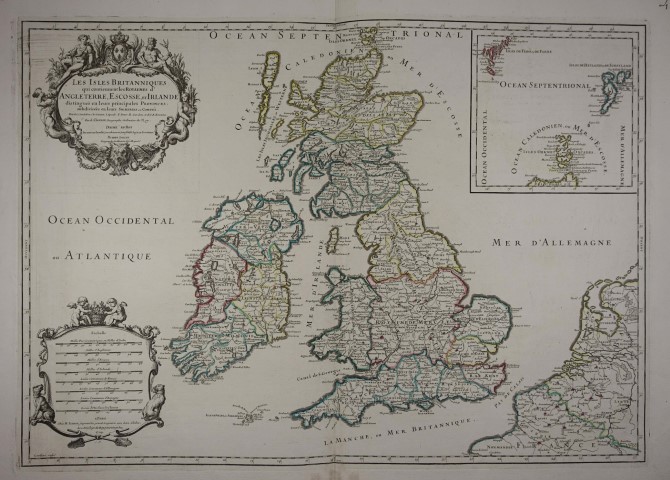 Les Isles Britanniques qui contiennent les Royaumes díAngleterre, Escosse, et Irlande, distingués en leurs principales Provinces: subdivisées en leurs Shireries ou Comtés. Grenzkolorierte Kupferstich-Karte von Cordier n. Nicolas Sanson. Paris, Hubert Iaillot 1709, 48 x 61,5 cm
Oben rechts Insertkarte mit den Orkney-, Shetland- und Färöerinseln.- Breitrandig. # Copper engraved map. Contemporary colored boundaries.- Large format map of the British Isles, with two large cartouches and insert map with the Orkney, Shetland and Faroe Islands. (England, Irland, Schottland, Great Britain, United Kingdom) |
|
| Bestellnummer:L2355 | EUR 350,00 / Bestellen |
| Grossbritannien |
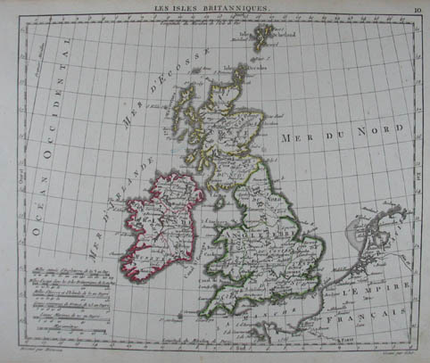 Les Isles Britanniques. Grenzkolorierte Kupferstich-Karte aus Herisson "Atlas portatif" Paris, Desray 1806, 18 x 21,5 cm
# Copper engraving with original outline color.- (Great Britain, United Kingdom) |
|
| Bestellnummer:L1475 | EUR 55,00 / Bestellen |
| Großbritannien |
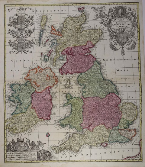 Tabula Novissima Accuratissima Regnorum Angliae, Scotiae, Hiberniae. Altkolorierte Kupferstich-Karte. Augsburg, Matthäus Seutter um 1730, 57,5 x 49 cm
Prachtvolle Karte mit 3 Kartuschen: links oben die 3 Wappenschilder Englands, Schottlands und Irlands; rechts oben ein Porträt von King George I. mit dem Wappen des Hauses Hannover und unten links Maßstabskartusche mit dem Wappen des Hauses Stuart und der Rettung Andromedaís durch Perseus.- Kleine Wurmspuren im Mittelbug. # One of the most decorative maps of the British Isles to appear in an 18th Century Atlas; engraving with original colours.- Small worm marks in the center fold. (England, Schottland, Irland, Great Britain, United Kingdom) |
|
| Bestellnummer:L2373 | EUR 260,00 / Bestellen |
| Irland |
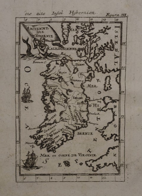 Ancienne Isle díHibernie / die alte Insul Hybernien. Kupferstich aus A. M. Mallet "Beschreibung Des gantzen Welt-Kreises" Frankfurt, J. A. Jung 1719, 14,2 x 10 cm
Alain Manesson Mallet (* 1630 in Paris; 1706 ebenda) war ein französischer Kartograph und Ingenieur. Sein Hauptwerk "Description de LíUnivers" erschien erstmals 1683 in fünf Bänden in Paris.- Schönes, breitrandiges Exemplar, ohne Text auf der Rückseite. # Engraved map Ireland.- Nice, wide-margined copy from the second, revised German edition of Mallet s "Description de l Univers" with additional German title on top; without text on the back. (Ireland, Eire, Nordirland) |
|
| Bestellnummer:L2310 | EUR 40,00 / Bestellen |
| Irland |
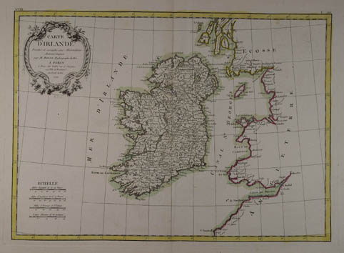 Carte DíIrlande Projettée et assujiettie aux Observations Astronomiques par M. Bonne, Hydrographe du Roi. Grenzkolorierte Kupferstich-Karte n. Rigobert Bonne aus "Atlas Moderne ou Collection de Cartes sur Toutes les Parties du Globe Terrestre". Paris, Jean Lattré 1771, 30 x 42 cm
# Decorative engraved map with original outline hand-colouring, wide margins.- (Ireland, Eire, Nordirland) |
|
| Bestellnummer:L1939 | EUR 160,00 / Bestellen |
| Irland |
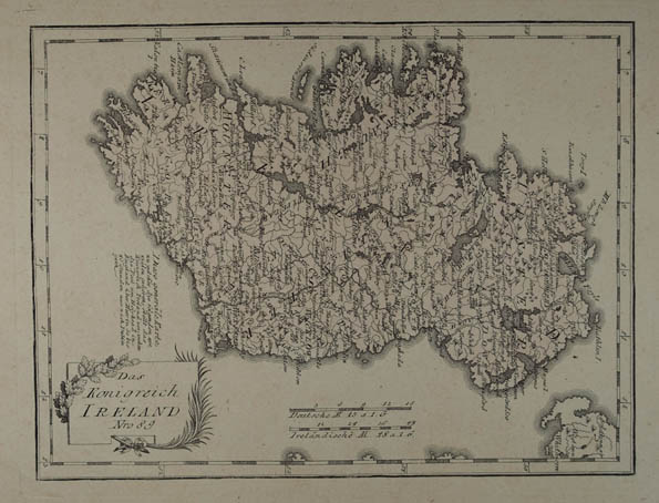 Das Konigreich Ireland Nro 89. Kolorierte Kupferstich-Karte aus Reilly "Schauplatz der fünf Theile der Welt” Wien 1791, 21 x 28 cm
Atlantes Austriaci I/1, 86 (Rei A 89).- Gutes Exemplar mit zartem Kolorit # Engraved map with contemporary coloring.- (Ireland, Eire, Nordirland) |
|
| Bestellnummer:L2038 | EUR 90,00 / Bestellen |
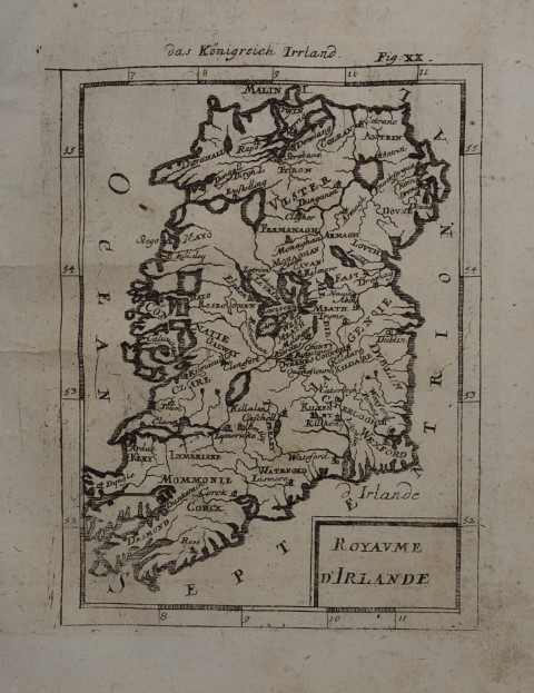
| Irland |
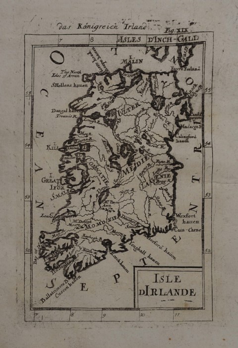 Isle d Irlande / das Königreich Irland. Kupferstich aus A. M. Mallet "Beschreibung Des gantzen Welt-Kreises" Frankfurt, J. A. Jung 1719, 15 x 10,2 cm
Alain Manesson Mallet (* 1630 in Paris; 1706 ebenda) war ein französischer Kartograph und Ingenieur. Sein Hauptwerk "Description de LíUnivers" erschien erstmals 1683 in fünf Bänden in Paris.- Schönes, breitrandiges Exemplar, ohne Text auf der Rückseite. Gering fleckig. # Engraved map of Ireland.- Nice, wide-margined copy from the second, revised German edition of Mallet s "Description de l Univers" with additional German title on top; without text on the back.- (Ireland, Eire, Nordirland) |
|
| Bestellnummer:L2326 | EUR 60,00 / Bestellen |
| Irland |
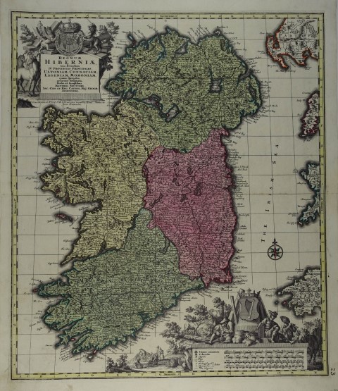 Regnum Hiberniae, tam secundum IV Provinvias Principales Ultoniam, Connaciam, Lageniam, Momoniam, quam speciales, accuratae designata, studio et sumptibus..... Altkolorierte Kupferstich-Karte von Matthäus Seutter, Augsburg um 1740, 57,5 x 49,5 cm
Bonar-Law 72.- Dekorative Karte von Irland mit den Provinzen Ulster ( Donegal, Cavan,Monaghan, sowie Antrim, Armagh, Derry/Londonderry, Down, Fermanagh, Tyrone - heute Nordirland), Connacht ( Galway, Mayo, Sligo, Leitrim und Roscommon), Leinster (Louth, Meath, Dublin, Wicklow, Wexford, Kilkenny, Carlow, Laois, Offaly, Kildare, Westmeath und Longford) und Munster (Clare, Cork, Kerry, Limerick, Tipperary und Waterford).- Rechts unten hs. Nummer, gutes Exemplar mit kräftigem Kolorit. # Copper engraving in original colours.- (Ireland, Eire, Nordirland) |
|
| Bestellnummer:L2158 | EUR 420,00 / Bestellen |
| Irland |
 Royaume díIrlande / das Königreich Irrland. Kupferstich aus A. M. Mallet "Beschreibung Des gantzen Welt-Kreises" Frankfurt, J. A. Jung 1719, 15 x 11,2 cm
Alain Manesson Mallet (* 1630 in Paris; 1706 ebenda) war ein französischer Kartograph und Ingenieur. Sein Hauptwerk "Description de LíUnivers" erschien erstmals 1683 in fünf Bänden in Paris.- Schönes, breitrandiges Exemplar, ohne Text auf der Rückseite. Gering fleckig. # Engraved map Ireland.- Nice, wide-margined copy from the second, revised German edition of Mallet s "Description de l Univers" with additional German title on top; without text on the back.- Slightly stained. (Ireland, Eire, Nordirland) |
|
| Bestellnummer:L2325 | EUR 50,00 / Bestellen |
| Irland |
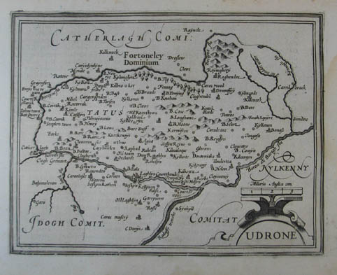 Udrone. Kupferstich-Karte aus Mercator "Atlas Minor". Amsterdam, Hondius 1607, 14 x 18 cm
Im Randbereich leicht braunfleckig, rechts etw. wasserrandig. # A decorative map of the Carlow region. (Ireland, Eire, Nordirland) |
|
| Bestellnummer:L994 | EUR 100,00 / Bestellen |
| Irland - Ulster |
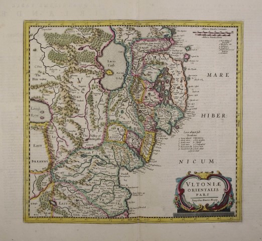 Ultoniae orientalis pars. Altkolorierte Kupferstich-Karte aus "Nouveau Theatre du Monde ou Nouvel Atlas". Amsterdam, Henricus Hondius 1641, 35 x 38 cm
Mit französischem Text verso.- Breitrandiges, schön koloriertes Exemplar, # Engraved map with contemporary coloring.- Shows the eastern part of Ulster, featuring Down and Antrim Counties in Northern Ireland.- Verso French text.- Wide margins, beautiful coloring.- (Ireland, Eire, Nordirland) |
|
| Bestellnummer:L2476 | EUR 220,00 / Bestellen |
| Isle of Man |
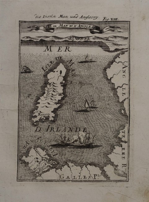 Is de Man et díAnglesey / die Inseln Man und Anglesey. Kupferstich aus A. M. Mallet "Beschreibung Des gantzen Welt-Kreises" Frankfurt, J. A. Jung 1719, 14,5 x 10,5 cm
Alain Manesson Mallet (* 1630 in Paris; 1706 ebenda) war ein französischer Kartograph und Ingenieur. Sein Hauptwerk "Description de LíUnivers" erschien erstmals 1683 in fünf Bänden in Paris.- Schönes, breitrandiges Exemplar, ohne Text auf der Rückseite. Gering fleckig. # Engraved map Isle of Man & Anglesey, Irish Sea.- Nice, wide-margined copy from the second, revised German edition of Mallet s "Description de l Univers" with additional German title on top; without text on the back.- (Ireland,) |
|
| Bestellnummer:L2327 | EUR 70,00 / Bestellen |
| Isle of Wight |
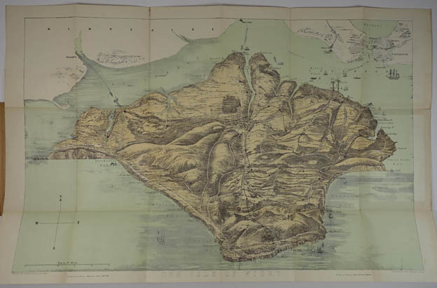 Bird s Eye View of the Isle of Wight, shewing its Towns, Villages, Hills, Hamlets, Chines, Carriage Roads, Railways &c., at one View. Being the Best Tourists Guide Published. Mehrf. gef. Farblithographie v. Lewis Becker nach Arthur Fowles. Ventnor, James Briddon (hier überklebt L. Wheeler) um 1875, in OPbd. 39,5 x 62 cm.
# Multi-fold color lithograph in the original cardboard cover, created by Arthur Fowles and engraved by Lewis Becker; published by J. Briddon (this copy by L. Wheeler).- Good copy. (Great Britain, England) |
|
| Bestellnummer:L2101 | EUR 100,00 / Bestellen |
| Isle of Wight |
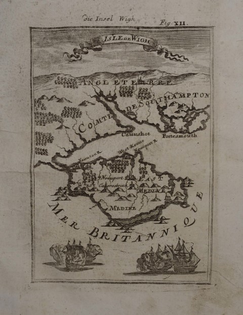 Isle de Wigh / die Insel Wigh. Kupferstich aus A. M. Mallet "Beschreibung Des gantzen Welt-Kreises" Frankfurt, J. A. Jung 1719, 14,2 x 10 cm
Alain Manesson Mallet (* 1630 in Paris; 1706 ebenda) war ein französischer Kartograph und Ingenieur. Sein Hauptwerk "Description de LíUnivers" erschien erstmals 1683 in fünf Bänden in Paris.- Schönes, breitrandiges Exemplar, ohne Text auf der Rückseite. # Engraved map of the Isle of Wight.- Nice, wide-margined copy from the second, revised German edition of Mallet s "Description de l Univers" with additional German title on top; without text on the back. (Great Britain, United Kingdom) |
|
| Bestellnummer:L2311 | EUR 50,00 / Bestellen |
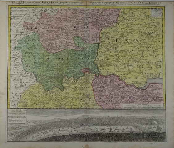
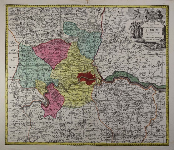
| London |
 Delineatio ac finitima Magnae Britanniae Metropoleos Londini ad novißimam Normam repraesentata et excuda...... Altkolorierte Kupferstich-Karte von Matthäus Seutter, Augsburg um 1740, 49,5 x 57,5 cm
Dekorative Karte von London und Umgebung. Zeigt St. Albans, Hatfield, Gravesend, Reigate, Leatherhead und Chertsey. Titel in Latein, Details und Legende in Englisch. - Gutes Exemplar mit kräftigem Kolorit. # Copper engraving in original colours.- A map of London and its environs, reaching St Albans in the north, clockwise to Hatfield, Gravesend, Reigate, Leatherhead and Chertsey, with the roads marked.Although the title is in Latin, the detail and key are in English. (Great Britain, United Kingdom) |
|
| Bestellnummer:L2159 | EUR 420,00 / Bestellen |
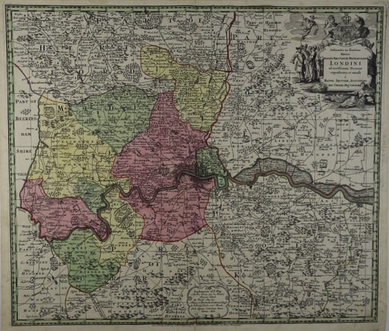
| London |
 Regionis, quae est circa Londinum, specialis repraesentatio geographica : ex autographo maiori Londinensi desumta.... Ausführliche Geographische Vorstellung der Gegend um London.... . Altkolorierte Kupferstich-Karte von Thomas Bowles, Homannís Erben, Augsburg 1741, 51 x 57,5 cm (Plattenrand)
Dekorative Karte von London und Umgebung. Zeigt die Grafschaften Hertfordshire, Essex, Kent, Surrey und Middlesex. Unten Panoramabild "London u. Westminster von der Sud-Seyte".- Unterer Rand mit kl. Braunfleck u. gering wasserrandig.- Gutes Exemplar mit kräftigem Kolorit. # Copper engraving in original colours.- Showing the area around London with the counties Hertfordshire, Essex, Kent, Surrey and Middlesex. Below a large panoramic view of London and Westminster with ships on the River Thames. (Great Britain, United Kingdom) |
|
| Bestellnummer:L2160 | EUR 420,00 / Bestellen |
| London - Umgebung |
 Delineatio ac finitima Regio Magnae Brittaniae Metropoleos Londini ad Novissimam Normam repraesentata et excusa. Altkolorierte Kupferstich-Karte mit großer unkolor. figürl. Kartusche von M. A. Lotter bei T. C. Lotter in Augsburg 1764, 50 x 57,5 cm.
Detaillierte Karte von London und Umgebung mit Teilen von Middlesex, Essex und Surrey.- Breitrandig.- Schönes kräftiges Kolorit # Copper engraving with original colour; a very good copy with wide margins. (England, London, Great Britain, United Kingdom) |
|
| Bestellnummer:L2375 | EUR 380,00 / Bestellen |
| Montgomery and Merioneth |
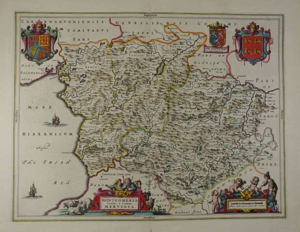 Montgomeria comitatus et comitatus Mervinia. Altkolorierte Kupferstich-Karte v. Joan Blaeu. Amsterdam, 1645, 38 x 50 cm
Schönes Exemplar mit kräftigem Kolorit. # Engraved map with original colours.- Verso text: French (Great Britain, United Kingdom) |
|
| Bestellnummer:L2299 | EUR 250,00 / Bestellen |
| Orkney |
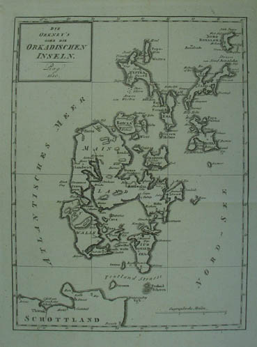 Die Orkney`s oder die Orkadischen Inseln. Kupferstich-Karte aus "Neueste Länder- und Völkerkunde" Prag 1810, 24 x 18 cm
# Copper engraving (Schottland, Scotland, Great Britain) |
|
| Bestellnummer:L1290 | EUR 75,00 / Bestellen |
| Schottland |
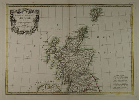 Carte Du Royaume DíEcosse Projettée et assujiettie aux Observations Astronomiques par M. Bonne, Hydrographe du Roi. Grenzkolorierte Kupferstich-Karte n. Rigobert Bonne aus "Atlas Moderne ou Collection de Cartes sur Toutes les Parties du Globe Terrestre". Paris, Jean Lattré 1787, 30 x 42 cm
# Decorative engraved map with original outline hand-colouring, showing Scotland and the Orkney and Shetland Islands, Outer Hebrides. Wide margins.- (Great Britain, United Kingdom, Scotland) |
|
| Bestellnummer:L1940 | EUR 140,00 / Bestellen |
| Schottland |
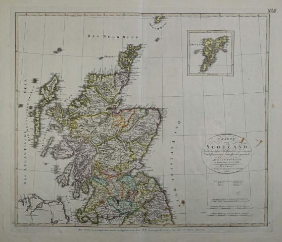 Charte von Scotland... entworfen und gezeichnet von August Stieler. Kolorierte Kupferstich-Karte. Weimar, Verlag des Geographischen Institutes 1804, 45 x 53 cm
Rechts oben Nebenkarte der Shetlandinseln.- Rechts oben handschr. Nummerierung, wenige Braunflecken, breitrandiges Exemplar. # Engraved map of Scotland with original colouring.- top right inset of Shetland Islands.- Few brown spots, wide-margined copy. (Great Britain, United Kingdom, Scotland) |
|
| Bestellnummer:L2471 | EUR 145,00 / Bestellen |
| Schottland |
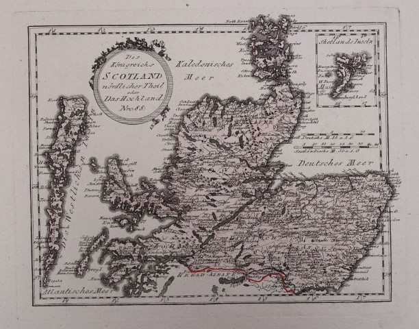 Des Königreichs Scotland nördlicher Theil oder das Hochland. Nro 88. Altkolorierte Kupferstich-Karte aus Reilly "Schauplatz der fünf Theile der Welt”. Wien um 1795, 23 x 29,5 cm (Plattenrand)
Atlantes Austriaci I/1, 86 (Rei A 88).- Zeigt Nordschottland mit den Highlands und den Hebriden, rechts oben Nebenkarte der Shetlandinseln.- Breitrandiges Exemplar. # Engraved map of the Northern part of Scotland with original colouring.-Shows Northern Scotland with the Highlands, Western Isles; top right inset of Shetland Islands.- A nice, very wide-margined copy. (Great Britain, United Kingdom, Scotland) |
|
| Bestellnummer:L2434 | EUR 60,00 / Bestellen |
| Schottland |
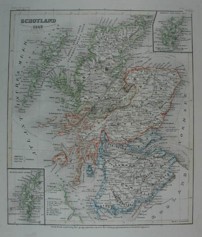 Schottland. Grenzkolorierte Stahlstich-Karte von Radefeld aus "Meyer`s Zeitungs-Atlas". Hildburghausen, Bibliograph. Institut 1849, 23,5 x 20 cm
Mit 2 Nebenkarten der Schetland Inseln und der Orkney Inseln.- Der Kartograph Carl Christian Franz Radefeld (Jena, 1788 - 1874) wurde bekannt durch seine Zusammenarbeit mit dem Verleger J. Meyer und seinem Haus Bibliographisches Institut. Insbesondere durch den "Atlas zum Handgebrauche für die Gesammte Erdbeschreibung" von 1841 und des "Grossen Hand-Atlas" von 1846.- (Scotland, Great Britain, United Kingdom) |
|
| Bestellnummer:L1242 | EUR 40,00 / Bestellen |
| Südengland |
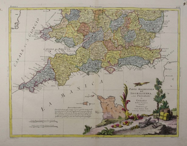 Parte Meridionale dellí Inghilterra, e del Principato di Galles di Nuova Projezione. Altkolorierte Kupferstich-Karte mit kolor. Kartusche v. Giuliano Zuliani u. G. Pitteri aus "Atlante novissimo" Venedig, Antonio Zatta 1778, 40 x 30 cm
Zeigt Südengland von Cornwall bis Kent und der Isle of Wight bis Leistershire, Shropshire und Norfolk. Ebenso die Kanalinseln und die nördliche Bretagne.- Kleines Wurmloch im unteren Rand, sonst schönes Exemplar.- # Engraved map with original color.- Large decorative (fully colored) title cartouche.- Good copy. (England, Great Britain, United Kingdom) |
|
| Bestellnummer:L2371 | EUR 150,00 / Bestellen |
| Wales - Schottland |
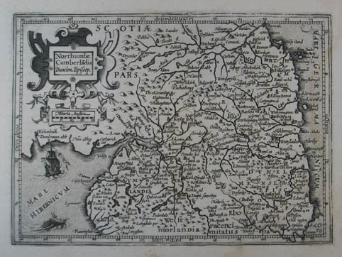 Northumbr. Cumberlandia Dunelm. Episcop. Kupferstich-Karte aus Mercator "Atlas Minor". Amsterdam, Hondius 1607, 13,5 x 18,5 cm
Im Randbereich leicht braunfleckig u. rechts etw. wasserrandig. # map of the north part of Wales and part of Scotland (Cumberland, Northumberland, Scotland, Great Britain, United Kingdom) |
|
| Bestellnummer:L992 | EUR 85,00 / Bestellen |
| Johannes Müller | Franz-Josef-Strasse 19 | A-5020 Salzburg | Telefon +43 (0) 664 / 2010925 | e-mail: office@antiquariat-mueller.at |