| Landkarten Australien - Ozeanien | Kunsthandlung Johannes Müller |
|
|
|
| Australien |
 Australien (Neu - Holland, Australland). Farblithographierte Karte von Ludwig Ewald aus "Bauerkeller s Handatlas der allgemeinen Erdkunde, der Länder- und Staatenkunde". Darmstadt, Bauerkeller s Präganstalt, Jonghaus & Venator 1849, 35,5 x 45 cm
Selten.- Zeigt auch noch Neuseeland.- Etw. braunfleckig, Ränder tls. auch etw. wasserfleckig. # Colourlithographed map of Australia and New Zealand; relief shown by hachures.- Slightly foxing, margins partly a little water-stained. (Australia, Oceania, New Zealand) |
|
| Bestellnummer:L2006 | EUR 150,00 / Bestellen |
| Australien |
 Australien. Grenzkolorierte Stahlstich-Karte v. H. Alt & Schröder aus "Stieler`s Hand-Atlas". Gotha, Justus Perthes 1872, 33,5 x 40,5 cm
Unten mit kl. Nebenkarten: "Sydney und Port Jackson".- # Steel engraved map with original outline color.- (Australia) |
|
| Bestellnummer:L2274 | EUR 85,00 / Bestellen |
| Australien |
 Das Austral-Continent oder Neu Holland nach Krusenstern, King, Flinders, Freycinet, Oxley, Stuart, Mitchell. Grenzkolorierte Stahlstich-Karte von C. F. Weiland und nach den Entdeckungen von Eyre, Frome, Grey, Stokes, Leichardt und Strzelecki vervollständigt von H. Kiepert aus "Hand-Atlas der Erde und des Himmels". Weimar, Geographisches Institut 1858, 47 x 57,5 cm
Unten mit 4 kl. Nebenkarten: I) Neu Süd Wales; II) Plan von Port-Jackson und Sidney; III) Bathurst - Melville; IV) Kolonie Süd-Australia.- Der Kartograph Carl Ferdinand Weiland (* 1782; 18. Mai 1847 in Gera) wirkte beim geographischen Institut in Weimar und wurde 1817 Nachfolger von Friedrich Wilhelm Streit.- Schönes, breitrandiges Exemplar. # Map of Australia showing counties in Western Australia, Northern counties, counties in Victoria and Van Diemens Land. Relief shown by hachures.- Nice example incorporating the recent explorations of Eyre, Frome, Grey, Stokes, Leichardt, und Strzeliecki. (Australia, Oceania) |
|
| Bestellnummer:L1613 | EUR 160,00 / Bestellen |
| Australien |
 Generalcharte von Australien nach dem Entwurfe des H. Joseph Marx Freiherrn v. Liechtenstern. Grenzkolorierte Kupferstich-Karte gezeichnet von Franz Svoboda u. Martin Hartl. Wien, Kunst- und Industrie-Comptoirs 1805, 49 x 67 cm
Dörflinger II, 562 (KIC 4 / 25).- Das auf der Karte dargestellte Gebiet reicht von Sumatra (Westen) bis zu den Marquesas (Osten) und von Neuseeland bis in die Breite von Nordjapan.- Theodor Freiherr von Liechtenstern (* 9. November 1799 in Wien; 1848) gilt neben Emil von Sydow als einer der Begründer der methodischen Schulkartographie und als ein Vorreiter der physischen Atlaskarte.- War mehrf. gefaltet, kl. restaurierter Einriß. # Engraved map with original outline hand-colouring.- Was folded several times, small restored tear. (Ozeanien, Neuseeland, Indischer Ozean, Pazifik, Oceania, Australia) |
|
| Bestellnummer:L1795 | EUR 320,00 / Bestellen |
| Australien |
 Karte von Neu Holland nach den neuesten Entdeckungen entworfen und gezeichnet von D. Friedr. Ludwig Lindner Professor der Geographie. Grenzkolorierte Kupferstich-Karte aus Friedrich Ludwig Lindner "Neueste Länder- und Völkerkunde". Weimar im Verlag des Geographischen Instituts 1815, 33,5 x 45 cm (Blatt)
Unten bis knapp über die Einfassung beschnitten.- # Decorative engraved map with original outline hand-colouring, showing the discoveries of the English, French and Dutch in different hand colors. The map shows a completed coastline.- Lower margin cut to the edge of the picture. (Australia) |
|
| Bestellnummer:L1947 | EUR 220,00 / Bestellen |
| Australien |
 Neu Holland. Grenzkolorierte Stahlstich-Karte von Kleinknecht aus "Meyerís Pfenning Atlas". Hildburghausen, Bibliograph. Institut 1838, 9 x 14 cm
Espenhorst, Petermann`s Planet I, 479, 3.2.- Miniaturkarte.- Mit drei Insetkarten: "Colonien am Schwan Flusse"; "Gegend von Hobartstown"; "Grafschaften in Neu-Süd-Wales".- Ränder etw. braunfleckig. # Engraved map with original outline colouring. (Australia) |
|
| Bestellnummer:L2030 | EUR 35,00 / Bestellen |
| Australien |
|
Neu Süd-Wales. Grenzkolorierte, lithographierte Karte in zwei Farben aus "Vollständiger Universal-Handatlas". Glogau, Carl Flemming ca 1853, 39 x 32,5 cm
# Colourlithographed map with orig. outline color. Map of New South Wales divided into 19 land districts, with inset plan of Sydney.- waterstained (Australia,) |
|
| Bestellnummer:L2014 | EUR 120,00 / Bestellen |
| Australien |
 Nieuw Zuid-Wales, Victoria, Tasmania. Farblithographierte Karte. Amsterdam, Emrik & Binger 1882, 20 x 15 cm
# Lithographed map with original outline hand color. Dutch issued.- New South Wales- Australia (Indischer Ozean, Pazifik, Oceania, Australia) |
|
| Bestellnummer:L2287 | EUR 40,00 / Bestellen |
| Australien |
 Queensland. Farblithographierte Karte. Amsterdam, Emrik & Binger 1882, 20 x 15 cm
# Lithographed map with original outline hand color. Dutch issued.- (Indischer Ozean, Pazifik, Oceania, Australia) |
|
| Bestellnummer:L2288 | EUR 40,00 / Bestellen |
| Marianen |
 Carte de l Archipel de St Lazare ou les Isles Marianes. Kupferstich-Karte v. Jacques-Nicolas Bellin aus Prevost "Histoire Generale Des Voyages". Paris 1752, 22,5 x 15,5 cm
Links unten Insetkarte der Insel Guam.- Der französische Kartograph Jacques-Nicolas Bellin (* 1703 in Paris; 21. März 1772 in Versailles) war von 1741 bis zu seinem Tod Ingenieur-Hydrograph der Marine.- # Copper engraving.- From the French edition of Prevostí general history of travel.- (Mikronesien, Ozeanien, Westpazifik, Oceania) |
|
| Bestellnummer:L1601 | EUR 45,00 / Bestellen |
| Mikronesien |
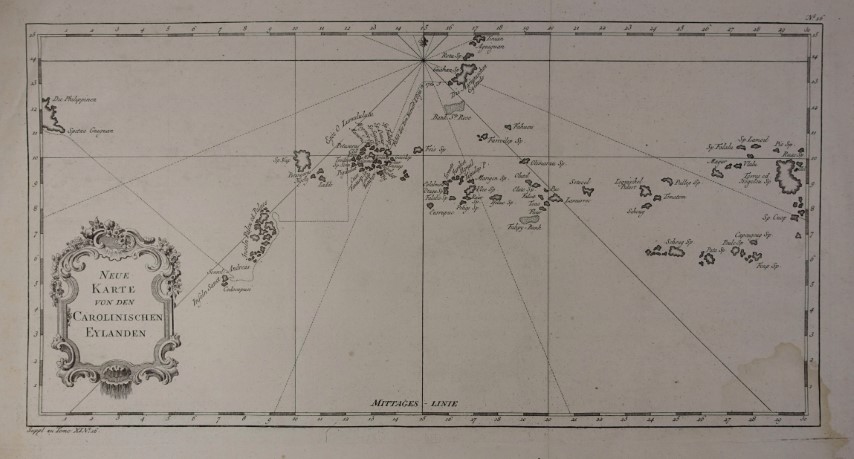 Neue Karte von den Carolinischen Eylanden. Kupferstich-Karte v. Jacques-Nicolas Bellin aus Provost "Allgemeine Historie der Reisen zur Wasser und zu Lande: oder Sammlung aller Reisebeschreibungen." Leipzig 1764,
Im äußersten Westen des Pazifiks, weit verstreut zwischen den Philippinen und Marshallinseln, erstrecken sich im Inselgebiet von Mikronesien die Karolinen (Caroline Islands: Chuuk, Kosrae und Pohnpei). Im Westen noch die Gruppe der Palau - Inseln.- Faltungen geglättet, rechts unten leichter Wasserrand. # Caroline Islands or Caroline Atoll, (Pazifik) |
|
| Bestellnummer:L2602 | EUR 90,00 / Bestellen |
| Neukaledonien - Fidschi |
 Nieuw-Caledonie, Fidsji Eil. Farblithographierte Karte. Amsterdam, Emrik & Binger 1882, 15 x 20 cm
# Lithographed map with original outline hand color. Dutch issued.- Shows the Pacific Ocean between New Caledonia and Fiji. (Pazifik, Nouvelle-Calédonie, Republic of Fiji,) |
|
| Bestellnummer:L2286 | EUR 45,00 / Bestellen |
| Neuseeland |
 Neu Seeland Nord Insel (Te Ika a Maui). Farblithogr.-Karte aus R. Grundmann "Allgemeiner Missions-Atlas". Gotha, Justus Perthes 1870, 31,5 x 22 cm
Mit 2 Bll. beigeheftetem Text.- Mit 8 kl. Nebenkarten (u.a. Isthmus von Aukland, Insel Bai, Hokianga, Unter Waikato, Nord Taranaki). # Color lithography published by Justus Perthes 1870 with accompanying text. (Polynesien, Polynesia, New Zealand) |
|
| Bestellnummer:L1634 | EUR 75,00 / Bestellen |
| Ozeanien |
 Australasie et Polynesie. Grenzkolorierte Kupferstich-Karte aus Herisson "Atlas portatif" Paris, Desray 1806, 17,5 x 22 cm
# Copper engraving with original outline color.- (Ozeanien, Neuseeland, Indischer Ozean, Pazifik, Oceania, Australia) |
|
| Bestellnummer:L1492 | EUR 70,00 / Bestellen |
| Ozeanien |
 Australien. Grenzkolorierte Kupferstich-Karte v. W. Kratz u. I. u. C. Poppey. Neu bearbeitet von C. Gräf aus "Hand-Atlas der Erde und des Himmels". Weimar, Geographisches Institut 1857, 52,5 x 65 cm
Mit 5 Insetkarten: Tasmania oder Van Diemens Land; Neu Seeland Nuitireni (New Zealand); Hawaii Archipelagus (Sandwich-Inseln); Tahiti Archipelagus.- # Engraved map. Boundaries hand coloured; Larger scale insets of Tasmania oder Van Diemens Land. Neu Sealand. Hawaii Archipelagus. Tahiti Archipelagus. (Polynesia, Oceania, Fidji, New Zealand, Melanesia, Micronesia) |
|
| Bestellnummer:L2296 | EUR 110,00 / Bestellen |
| Ozeanien |
 Carte de L Oceanie contenant L Australie, La Polynesie et Les Iles Asiatiques. Grenzkolorierte Kupferstich-Karte v. Pierre Lapie gestochen v. A. J. Lallemand aus "Atlas Universel de Geographie". Paris 1829, 39,5 x 54,5 cm
Oberst Pierre M. Lapie war ein französischer Kartograph und Kupferstecher. Er war der Vater des Kartographen Alexandre Emile Lapie, mit dem er eng zusammenarbeitete.- Schönes, breitrandiges Exemplar. # Engraved map with original outline hand-colouring.- A fine first edition example of M. Lapie s 1830 map of Australia, New Zealand, Polynesia, and the east India Islands. This map covers from Southeast Asia eastward as far as the remote Polynesian islands of elisabeth and Henderson, and from Japan Southwards to include all of Australia, Tasmania, and New Zealand. The map identifies countless islands throughout Polynesia including the major archipelagos: the Marquesas, the Friendly Islands the Sandwich Islands (Hawaii), Tahiti, New Hebrides, and the Solomon Islands.This map was engraved by Armand Joseph Lallemand as plate no. 38 in the first edition of M. Lapie s important Atlas Universel. This map, like all maps from the Atlas Universel features an embossed stamp from the Lapie firm. (Ozeanien, Neuseeland, Indischer Ozean, Pazifik, Oceania, Australia) |
|
| Bestellnummer:L1612 | EUR 240,00 / Bestellen |
| Ozeanien |
 Charte von Australien berichtigt im November 1812. Grenzkolorierte Kupferstich - Karte aus "Neueste Länder- und Völkerkunde". Prag 1815, 41 x 29,5 cm
Alte Faltungen geglättet.- # Engraved map with original outline hand-colouring.- Fine map of Oceana, based issued shortly after Krusenstern s voyage to the region; It divides Australia in two parts: the western part "Neu Holland vormals Ulimaroa" and the eastern half as "Neu Sud Wales 1770 entd. oder die eng. Stadtthalterschaft Sydney-Cove".- Smoothed out creases.- (Ozeanien, Neuseeland, Indischer Ozean, Pazifik, Oceania, Australia) |
|
| Bestellnummer:L1907 | EUR 160,00 / Bestellen |
| Ozeanien |
 Der Grosse Ocean und Australien. Grenzkolorierte Stahlstich-Karte von Radefeld aus "Meyer`s Zeitungs-Atlas". Hildburghausen, Bibliograph. Institut 1849, 21,5 x 26 cm
Der Kartograph Carl Christian Franz Radefeld (Jena, 1788 - 1874) wurde bekannt durch seine Zusammenarbeit mit dem Verleger J. Meyer und seinem Haus Bibliographisches Institut. Insbesondere durch den "Atlas zum Handgebrauche für die Gesammte Erdbeschreibung" von 1841 und des "Grossen Hand-Atlas" von 1846.- # Steel engraved map with original outline color.- (Ozeanien, Neuseeland, Indischer Ozean, Pazifik, Oceania, Australia) |
|
| Bestellnummer:L1199 | EUR 35,00 / Bestellen |
| Ozeanien |
 Karte von Polynesien. Gezeichnet v. E. G. Ravenstein aus "Meyer`s Hand-Atlas". Hildburghausen, Bibliographisches Institut 1869, 33,5 x 44 cm
Rechts mittig kleine Insetkarte "Galapagos Ins.". Rechts unten Insetkarte "Die grösseren Fidshi Inseln" und Insetkarte "Hawaii (Sandwich Inseln) mit Detailkarte "Honolulu". Links unten kleine Insetkarte "Tahiti, Otaheite".- # Engraved map with original outline hand-colouring.- Map of Polynesia with Australia, Sandwich Islands, Marquesas, New Caledonia, Micronesia, Papua New Guinea, New Zealand and with five inset maps: Tahiti, the Greater Fiji Islands, Hawaii, Honolulu, Galapagos Islands.-Fine copy (Polynesia, Oceania, Fidji, New Zealand, Melanesia, Micronesia) |
|
| Bestellnummer:L2295 | EUR 60,00 / Bestellen |
| Ozeanien |
 Karte von Polynesien. Grenzkolorierte Stahlstich-Karte nach Ernst Georg Ravenstein aus "Meyer`s Hand-Atlas". Hildburghausen, Bibliograph. Institut 1867, 34 x 44 cm
Rechts mittig kleine Insetkarte "Galapagos Ins.". Rechts unten Insetkarte "Die grösseren Fidshi Inseln" und Insetkarte "Hawaii (Sandwich Inseln) mit Detailkarte "Honolulu". Links unten kleine Insetkarte "Tahiti, Otaheite".- # Engraved map with original outline hand-colouring.- Map of Polynesia with Australia, Sandwich Islands, Marquesas, New Caledonia, Micronesia, Papua New Guinea, New Zealand and with five inset maps: Tahiti, the Greater Fiji Islands, Hawaii, Honolulu, Galapagos Islands.-Fine copy (Polynesia, Oceania, Fidji, New Zealand, Melanesia, Micronesia) |
|
| Bestellnummer:L1993 | EUR 60,00 / Bestellen |
| Ozeanien |
 LíOceanie. Altkolorierte, lithographierte Karte v. Alexandre Delamarche aus "Atlas Delamarche Geographie moderne". Paris, um 1865, 29 x 42,5 cm
Unten mit 2 kl. Nebenkarten: "Archipel Taiti" u. "Archipel des Marquises".- # Lithographed map with original colour.- Map shows some cities and settlements on the islands of the South Pacific, Australia, and islands between Asia and Australia. Insets: "Archipel Taiti" [Taiti Archipelago] and "Archipel des Marquises" [Des Marquises Archipeligo]. (Ozeanien, Neuseeland, Indischer Ozean, Pazifik, Oceania, Australia) |
|
| Bestellnummer:L2275 | EUR 70,00 / Bestellen |
| Ozeanien |
 Oceania. Grenzkolorierte Stahlstich-Karte v. Keith Johnston aus "General Atlas". Edinburgh & London, William Blackwood 1861, 44 x 57 cm
Unten mit 3 Insetkarten: Western Australia; Tasmania u. New Zealand.- # Engraved map. Boundaries hand coloured; Larger scale insets of Western Australia (which shows explorers tracks), Tasmania and New Zealand. |
|
| Bestellnummer:L2297 | EUR 55,00 / Bestellen |
| Ozeanien |
 Océanie. Altkolorierte Kupferstich-Karte v. Ch. Dyonnet nach A.H. Dufour aus Armand Le Chevalier "Atlas Universel". Paris 1863, 55 x 74 cm
Unten mit 5 Insetkarten: Südost-Australien; Neukaledonien, Marquesas Inseln, Thaiti und den Gambierinseln.- Schöne, großformatige Karte. # Engraved map by Dyonnet with 5 Inserts: Southeast Australia, New Caledonia, Marques Islands, Thaiti and the Gambier Achipel.- Contemporary coloring; beautiful, large format map. |
|
| Bestellnummer:L2369 | EUR 140,00 / Bestellen |
| Johannes Müller | Franz-Josef-Strasse 19 | A-5020 Salzburg | Telefon +43 (0) 664 / 2010925 | e-mail: office@antiquariat-mueller.at |